


The Berlin Wall was a guarded concrete barrier that physically and ideologically divided Berlin from 1961 to 1989. Constructed by the German Democratic Republic, starting on 13 August 1961, the Wall completely cut off West Berlin from surrounding East Germany and from East Berlin until government officials opened it in November 1989. Its demolition officially began on 13 June 1990 and finished in 1992. The barrier included guard towers placed along large concrete walls, accompanied by a wide area that contained anti-vehicle trenches, "fakir beds" and other defenses. The Eastern Bloc portrayed the Wall as protecting its population from fascist elements conspiring to prevent the "will of the people" in building a socialist state in East Germany. In practice, the Wall served to prevent the massive emigration and defection that had marked East Germany and the communist Eastern Bloc during the post-World War II period.GDR authorities officially referred to the Berlin Wall as the Anti-Fascist Protection Rampart, by implication ranking the NATO countries equal to fascists. The West Berlin city government sometimes referred to it as the "Wall of Shame", a term coined by mayor Willy Brandt in reference to the Wall's restriction on freedom of movement. Along with the separate and much longer Inner German border, which demarcated the border between East and West Germany, it came to symbolize physically the "Iron Curtain" that separated Western Europe and the Eastern Bloc during the Cold War.
 Bahnhof Velten
281 km
Ein schöner Ort gewesen um sich nach der Schule mit den Freunden zu verabreden und be... Campo de concentração de Oranienburg
282 km
Campo de concentração de Oranienburg foi um dos primeiros centros de detenção estabel... Staaken
285 km
is a locality at the western rim of Berlin within the borough of Spandau.GeographySta... Falkenhagener Feld
287 km
Falkenhagener Feld is a German locality (Ortsteil) of Berlin in the borough (Bezirk) ... Berlin-Falkenhagener Feld
287 km
Berlin-Falkenhagener Feld est un des neuf quartiers de l'arrondissement de Spandau da... Jagdschloss Glienicke
288 km
Ein sehr geschichtsträchtiger Ort, das Schloss liegt neben einem uralten Fernweg und ... Schloss und Landschaftsgarten Pfaueninsel
289 km
Sehr schöne Insel, die Erholung beginnt schon auf der Fähre. Die Wege sind recht gut ...
Bahnhof Velten
281 km
Ein schöner Ort gewesen um sich nach der Schule mit den Freunden zu verabreden und be... Campo de concentração de Oranienburg
282 km
Campo de concentração de Oranienburg foi um dos primeiros centros de detenção estabel... Staaken
285 km
is a locality at the western rim of Berlin within the borough of Spandau.GeographySta... Falkenhagener Feld
287 km
Falkenhagener Feld is a German locality (Ortsteil) of Berlin in the borough (Bezirk) ... Berlin-Falkenhagener Feld
287 km
Berlin-Falkenhagener Feld est un des neuf quartiers de l'arrondissement de Spandau da... Jagdschloss Glienicke
288 km
Ein sehr geschichtsträchtiger Ort, das Schloss liegt neben einem uralten Fernweg und ... Schloss und Landschaftsgarten Pfaueninsel
289 km
Sehr schöne Insel, die Erholung beginnt schon auf der Fähre. Die Wege sind recht gut ...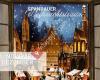 Spandauer Weihnachtstraum
289 km
War lange nicht mehr hier. Ist immer noch schön. Ich finde die Verbindung von vielen ... Rathaus Spandau
289 km
Rathaus Spandau is one of the western termini of Berlin U-Bahn line U7 (the other one... Rathaus Spandau
289 km
Das Rathaus Spandau wurde von den Architekten Heinrich Reinhardt und Georg Süßenguth ... St. Nikolai
289 km
Sehr gut erhaltene Kirche. Am 2. Advent fand ein schönes Konzert statt, welches allen... Bullengraben
289 km
Der schönste Weg um von Staaken Nennhauser Damm bis fast zu den Spandau Arcaden Elsfl... Spandau Citadel
289 km
Sehr sehenswert! Ich habe am Donnerstag die Zitadelle besucht, da sind die Öffnungsze... Valentinswerder
289 km
Insel mit vielen Bäumen, Ruhe und Ferienhäuser oder sogar dauerhaft bewohnte. Keine ... Imchen
290 km
Imchen ist der Name einer unbewohnten Flussinsel der Havel im Berliner Ortsteil Klado... Maienwerder
290 km
Sauberes Wasser Gut mit den Öffentlichen und dem Auto zu erreichen, Park Möglichkeite... Scharfenberg
290 km
Tolle Ankerplätze rund um Scharfenberg. Ein Kuckuck bewacht die Insel und weckt die B... Helmholtz-Zentrum Berlin für Materialien und...
290 km
Das Helmholtz-Zentrum Berlin für Materialien und Energie, bis zum 4. Juni 2008 Hahn-M...
Spandauer Weihnachtstraum
289 km
War lange nicht mehr hier. Ist immer noch schön. Ich finde die Verbindung von vielen ... Rathaus Spandau
289 km
Rathaus Spandau is one of the western termini of Berlin U-Bahn line U7 (the other one... Rathaus Spandau
289 km
Das Rathaus Spandau wurde von den Architekten Heinrich Reinhardt und Georg Süßenguth ... St. Nikolai
289 km
Sehr gut erhaltene Kirche. Am 2. Advent fand ein schönes Konzert statt, welches allen... Bullengraben
289 km
Der schönste Weg um von Staaken Nennhauser Damm bis fast zu den Spandau Arcaden Elsfl... Spandau Citadel
289 km
Sehr sehenswert! Ich habe am Donnerstag die Zitadelle besucht, da sind die Öffnungsze... Valentinswerder
289 km
Insel mit vielen Bäumen, Ruhe und Ferienhäuser oder sogar dauerhaft bewohnte. Keine ... Imchen
290 km
Imchen ist der Name einer unbewohnten Flussinsel der Havel im Berliner Ortsteil Klado... Maienwerder
290 km
Sauberes Wasser Gut mit den Öffentlichen und dem Auto zu erreichen, Park Möglichkeite... Scharfenberg
290 km
Tolle Ankerplätze rund um Scharfenberg. Ein Kuckuck bewacht die Insel und weckt die B... Helmholtz-Zentrum Berlin für Materialien und...
290 km
Das Helmholtz-Zentrum Berlin für Materialien und Energie, bis zum 4. Juni 2008 Hahn-M...hinzufügen eines Belrin wall-stadtplans zu ihrer webseite;

Wir verwenden Cookies und andere Tracking-Technologien, um Ihr Surferlebnis auf unserer Website zu verbessern, Ihnen personalisierte Inhalte und gezielte Anzeigen anzuzeigen, unseren Website-Verkehr zu analysieren und zu verstehen, woher unsere Besucher kommen. Datenschutz-Bestimmungen
